Showing posts with label Rocks and Roads 11-15. Show all posts

Sunday, October 21, 2018

The Wash


[I originally wrote this in October 2011, but never posted this series on the local geology. The pictures are still worth seeing.]

A bare cone stands back from the road, beckoning you to come discover. It’s sides have already been marred by ATV drivers who took the challenge. Yesterday, I heeded its siren call.

I was coming back from the near arroyo when I thought I spied a path to its base, a sort of gently sloping, lowland route. It had the right come hither look, a promise it wouldn’t be hard on the knees.


I started back. The grass covering disappeared to expose the usual tan sand and clay.


Then the bared ground turned into a dry arroyo, a wash completely hidden from the road.


The wash turned into a maze of washes that might somehow, if I followed the right one, lead me back to the arroyo.


The cone became harder and harder to approach.


I turned and found the wash also connected to one that crosses the county road close to my house. I chickened out and took the low road home.

Wednesday, October 17, 2018

The Near Arroyo


[I originally wrote this in mid-October of 2011, but never posted this series on the local geology. The pictures are still worth seeing.]

The near arroyo shows the marks of man even more than the far one.

The road goes over, rather than through it. The local acequia dumps on the river side of the bridge, digging a hole where the water falls. As a result, the one side of the arroyo is more than twice as deep as the other.

Even when it’s not running, open sections of the ditch that runs back the Santa Cruz river collect rain water. After Wednesday’s rain, the point where it falls could be seen in the shelf of sand it carved in the bottom.


Three large culverts carry water under the road. They force water into narrow channels which dig nearly a foot into the soft ground on the upriver side. In the summer, the heat dries the land and the wind smooths the edges, eventually carrying away much of the temporary island.


This arroyo, like the far one, has its sources three or four miles away in the Barrancos badlands that parallel highway 285 that runs from Pojoaque to Española. The rains bring down debris and weeds, especially Russian thistles, that are stopped by the culverts and sometimes block them.

While I think of the arroyo as having two sides, the deep one caused by the acequia and the swallow one carved by the culverts, both acts of man appear on both sides.

Last summer, a lateral was added to the acequia that now dumps just before the bridge on the upstream side. However, with this year’s drought, it hasn’t had a chance to run enough yet to have much impact.

And, on the other side of the bridge, the water leaves the culverts in narrow channels that dig their own paths, especially on the side away from where the acequia dumps. Apparently, the two paths of merge and push the water to the one side.


The erosion caused by the mere existence of the bridge also endangers it. Last year, the local ditch association had to replace the culverts with longer ones and rebuild the concrete faces. At that time, they also added the stone reinforcements.

Note: Top picture is looking towards the badlands on the other side of the Rio Grande and the Jemez. The brown legs in the second and fourth pictures belong to the flume that carries over the ditch water that eventually finds its way to the far arroyo.

Sunday, October 14, 2018

The River Runs


[I originally wrote this in October 2011, but never posted this series on the local geology. The pictures are still worth seeing. The weather has been drying this year, though it is raining at the moment.]

Wednesday it rained, day and night.

Thursday noon when I went to the post office the river was running higher and faster, the color of caffè latte.

I thought, ah yes, of course, the river’s running. It rained. I didn’t think, I’m seeing the great shaping force of this part of the country roused from a long seasonal slumber.

I didn’t connect even though I’d spent the morning looking at Daniel Koning’s "Preliminary Geologic Map of the Española 7.5-minute Quadrangle" which shows a lopped triangle with the Rio Grande and Route 285 on the sides, the Rio Pojoaque to the south and the Santa Cruz river on the north just above where I was driving over the Griego bridge.

He shows the road near my house skirts what he labels a "geological contact." The soils to the river side have recent alluvial origins. The ones to the east date back to an earlier Tertiary period. Since the time before the great glaciers when the river began to connect the discrete basins of the rift valley, water has been digging and padding its channel.

It’s removed or redeposited the existing tertiary sediments, or perhaps both at the same or different times, and left a boundary area that needs no geologist to recognize.


I went back to today to the Griego Bridge to see the river at the point the Santa Cruz enters. The current was slower, but the water was still carrying dirt. Gravel and sand have been deposited where the dammed and controlled water flow of the one meets the less tamed Rio Grande.


Then I drove home and looked again at that "geological contact" out the car window. You could imagine the grass as some great sea lapping against dunes. And like ladies of a certain age who once were rivals and now nod when they meet, you can only guess their pasts from the differences in their outerwear, their vegetation.

Wednesday, October 10, 2018

Running Water


[I originally wrote this in October 2011, but never posted this series on the local geology. The pictures are still worth seeing. Hurricane Rosa in the Pacific probably contributed to our moisture last week. The current Atlantic hurricane, Michael, is near the Florida panhandle.]

Another hurricane in the western Caribbean, some more rain this morning.

We’re past the danger point this year, when water is a potential enemy. In late summer, before the first rain after a long drought, you worry the ground has become too hard to absorb water and it will run off the surface. Firefighters were especially concerned about Santa Clara canyon where heat from the Las Conchas fire had baked the soil.


When I first moved here, I could be flooded when water coming off the hill turned into a rolling sheet that gathered force as it moved, fed as it was, every inch, by more rain. Water poured through the joints in my the rail-tie retaining wall, until I stuffed broken tiles behind the cracks.

My uphill neighbor had worse problems. He’d built his house in an abandoned road bed which channeled the water his way. A few years ago, he got a backhoe and built a bunker behind his property which diverted the flow of water enough that I no longer was in its path.


At the corner of my property, the paved road makes a sweeping turn. People who live downhill regularly had their garages flooded as water running down the road, swollen by feeds from every driveway uphill, flowed down their drives. One year, a number of people also had their well houses inundated.

The curve is actually an intersection of three roads - or so the people who numbered the roads believed. The compacted dirt ranch road, which branches from the curve, also collects water from the paved road and sends it along the side of my property.

From there it flows towards the arroyo, collecting water from every break in its banks made by an ATV. This summer I could see where the water had penetrated from the surface, and where it has also been absorbed at the base, with a dry band between the two zones.


The ranch road continues on the other side, which means it feeds water into the arroyo from both sides.

I’m beginning to think one reason the arroyo is as wide as it is in that area is that the load of water has washed away more of the banks downstream. Since the water from the road would turn as soon as possible, it would move along the walls while the water coming from upstream would continue its path somewhere in the center.

Chamisa has taken advantage of the different flow rates to colonize the dryer areas between the banks. This has created the widened arroyo composed of platforms at the edges with some vegetation that drop into obvious water channels that move along two sides of islands anchored by chamisa.


Pictures
1. Ranch road going through the arroyo, 10/20/11, from top of the left bank; ATV tracks enter the arroyo on both sides of the curving road; my house is the one with the gray-white roof.

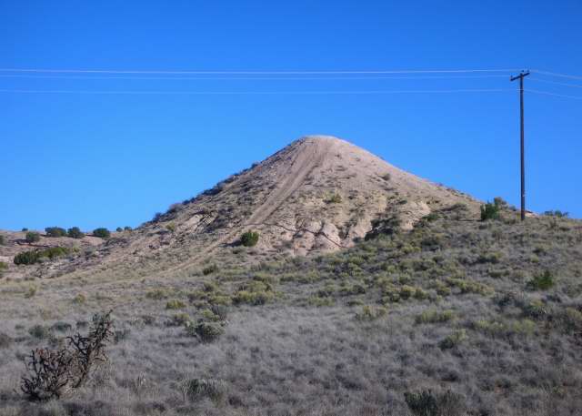
2. Hill behind my uphill neighbor’s house which is elevated on the right by the abandoned road bed marked by the fence posts. The berm runs parallel to the house.

3. Water running down hill between dead grasses on the west side of my house to drain into the ranch road, 8/21/11.

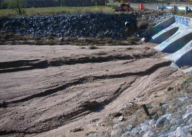
4. Bank of ranch road, 8/21/11.

5. Arroyo bottom, 9/11/11, from the platform at the base of the right bank.

Tuesday, September 25, 2018

Arroyo Walls


[I originally wrote this in October 2011, but never posted this series on the local geology. The pictures are still worth seeing.]

Appearances are deceiving.

When you walk through the far arroyo, the walls on the one side are tall and furrowed like the sandstone you see in pictures of Egypt’s Valley of the Kings. On the other side are low, sloping banks.


You assume the first are more substantial than the second. Don’t bet your climbing knees on it.

The surface here is the ungainly named Santa Fe Conglomerate, a lamination of sand, clay, and gravel. If you paw at the sand-clay layers they crumble in your finders. If you claw at the gravel it stays put until you increase your pressure.


The sculptured surfaces of the tall walls must be the result of constant wind action. When it falls, the rain pocks the skin, leaving small depressions. This year, soot from the Las Conchas fire collected on the ridges between.


The slovenly surfaces of the other result from rain which forms a glaze that resists the wind. When it washes out, however, it disintegrates faster than the clay it lay with. And, apparently when its surfaces can’t produce an adhesive, it leaches and, eventually, brings the clay down with it.