Showing posts with label Rocks and Roads 6-10. Show all posts
Sunday, September 23, 2018
Ditch Head
[I originally wrote this in October 2011, but never posted this series on the local geology. The pictures are still worth seeing.]
Today I went searching for the ditch head that feeds into the far arroyo. Head may not be the right word for the boundary between man and nature, but it’s all I can think of for the terminus.
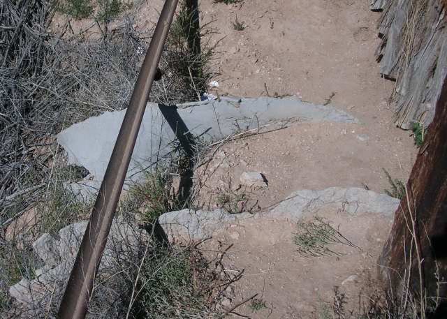
A concrete-lined irrigation ditch sweeps across the land between the near and far arroyos, going underground where it nears a road.
When it reaches the last piece of land, a neck of concrete, so thin it resembles plaster, channels the water away from the owner’s coyote fence.
It’s path from there is obvious, its course marked this time of year by brilliant leaf colors. There’s a long drop into a dry pool where water collects briefly.
What’s interesting is that after the drop the water’s route is no longer directed by the actions of humans, but follows ancient soil patterns.
The area lies on a long downward slope that angles south and west. The surface is crossed by ridges and valleys going roughly east-west. When nothing has disturbed the land, all’s covered with bunch grass.
When a low place is created in the land, perhaps by a road cut or an ATV trail, water has a new path. The softer soils absorb more of the water than the harder ones. The are dissolved from the developing walls, fall into the bottom, and are carried away by wind or water.
The harder soils stay longer, creating what look like eroded craters.
The acequia water, which runs most of the summer, apparently has lapped into soft spots of soil along its course that then began washing out. There are two major gullies uphill from the main water path. As they near each other and the main ditch path, they remain separated from each other by harder land.
The harder land looks much like the hard walls in the arroyo, and like those it doesn’t support as much vegetation as the softer soils that are eroding away.
The thing that has always surprised me about this man-made feeder to the arroyo is that it ends so abruptly that it endangers the houses near it. It’s hard to tell without digging before you build if a particular section of land here is on hard ground or soft.
The acequia association probably had no choice. After years of land disputes, and I suspect these particular houses, as well as mine, are sitting on some land grab, the pueblo probably wasn’t interested in making any more of its land attractive to interlopers and simply said no.
Unfortunately, no is not a word water understands.
Pictures top to bottom:
1. Ditch just outside the last fence.
2. Ditch as seen through the last fence.
3. Ditch from bottom looking up at same fence.
4. Land from across the ranch road; the white shed left of center is next to the arroyo end.
5. The current end of one of the wash outs feeding into the ditch path.
6. Two wash outs separated by a spit of land; the cottonwoods to the right mark the main ditch path.
7. Wash out between #5 and #6 showing bare hard rock and colonized softer soil.
Thursday, September 20, 2018
The Far Arroyo
[I originally wrote this in October 2011, but never posted this series on the local geology. The pictures are still worth seeing.]
I live between two arroyos, each about a quarter mile from the house. The one to the north I think of as the near arroyo because I cross it every time I drive into town. The other, to the south, I think of as the far arroyo because I have to walk across pueblo land to get to it.
The far arroyo changes its character every fifty or a hundred feet, partly because of humans. At the time the USGS map was revised for this quadrangle, the local ditch emptied into the near arroyo.
At some later time, a pipe was installed to carry water across the arroyo and out to the land downhill from me. A neighbor told me the land under his house and mine were once part of a ranch, perhaps the same one that survives beyond the arroyo. The acequia extension dumps a few hundred feet after it reaches pueblo ground.
The water has cut its own path to the far arroyo. From a distance it can be followed by the trees that grow along those banks, including those yellow cottonwoods pictured in the previous entry.
Thursday I walked down the arroyo to the point where the acequia feeder enters the arroyo. At that point the water has cut a path not much more than a foot deep.
The water flows immediately to the right where it has cut through the soft bottom land. The sand and clay wash away, leaving a path of gravel, the generic Santa Fe Conglomerate that covered this area before the rift opened.
Then, when the hard rock ends, the wall abruptly stops and the arroyo returns to bottomland vegetation.
That’s the point I turned back Thursday.
Tuesday, September 18, 2018
Rat Mazes
[I originally wrote this in October 2011, but never posted this series on the local geology. The pictures are still worth seeing.]
I finally got out to the far arroyo yesterday. I usually walk out on Sundays, but last weekend I thought, I can do that anytime now, I have something else I want to do today.
As I followed ATV paths through the prairie that sits above a ranch road, I realized I didn’t need to just walk where I usually did, I could go farther north and see if I could get to the point where the arroyo crosses the county road.
As I ventured farther, I thought, how much we turn our supposed encounters with wild nature into comfortable routines. Every weekend I go out at the same time, walk the same path. Am I just condemned to protect myself from novel stimuli?
But then I remembered there were things that created my patterns, and only some of them change with retirement. While I tell others the reason I walk is my doctor made some strong noises, the real reason is I want to watch how the plants change from week to week and use photographs as my notes.
I learned plants have many adaptions to the sun in this bright, high altitude environment. One is that as the air warms, the rate of photosynthesis increases. Before the rate goes beyond the limits of a plant’s ability to process the energy, it finds ways to protect itself. One obvious technique is deliberately wilting during the day.
A less obvious method is the alteration of its biochemistry so that flower parts that absorb energy from the sun in the morning begin to reflect it before noon. It’s called the violaxanthin cycle.
You can’t see the difference in reflectivity, but the camera can. It’s thus much easier to photograph a flower before it’s gone into its protective mode. This means, in the summer, I leave early and get home by 9:30.
A second natural factor that has influenced when I walk is the wind, which comes up when the air warms. My camera isn’t quick enough to catch flowers on moving stems. You don’t realize until you try to photograph them, how many plants are in motion when you can’t yet feel a breeze. Such flexibility is, no doubt, another adaption to our hostile environment.
There is a period of time available then, which may be longer now than in July, but is still absolutely determined by nature.
I suspect my limits are related to some lung problems I developed as a child. I grew up staying out of the sun and walking more slowly than others. There was probably some early feedback cycle that led me to look at the ground to shelter my head, which in turn meant I began to notice plants and stones, which in turn made me go slower to notice more. It can take me 90 minutes to walk a little over a mile here on a Sunday.
It so happens the arroyo has areas where there are many plants, and other areas where there are few. I’ve explored some of those areas, but haven’t gone back to see what’s beyond or to try to figure out why the plants appear where they do. My usual walk, limited as it is by natural factors and my personal level of energy, stays within the limits of predictably interesting plants.
Retirement can’t undo the consequences of my parents’ smoking and housekeeping habits.
I don’t think I have the same limits when it comes to exploring the land at a more general level. My car protects me from the heat. I haven’t yet discovered if the sun has any effects on my ability to photograph rocks.
For now, I drive out later in the morning, after the sun has reached that point that sends me indoors. I could leave earlier, but my mind is more creative when I first wake and I don’t want to get into the car until I’ve come to the end of that particular cycle. It’s when I write.
So, I’m venturing out slowly, sometimes looking at those things like La Bajada Hill that I deliberately ignored so I could get on with my life, get to Albuquerque to buy something. In a way, I’m building immunities. Once I’ve fully absorbed my near environment, then I can pass through it quickly to get to something new.
If, as I anticipate, I’m going to be spending time in motel rooms in places where the natural landscape is more interesting than the human one, this may become a welcome time hog.
The major difference retirement has made so far is that my adventures no longer need to be limited to the time on weekends that isn’t already committed to such chores as the weekly visit to the post office, but the time bands remain.
Pictures taken yesterday, from top to bottom are: 1- cottonwoods, 2 - strap-leaf spine aster, 3 - chamisa, 4 - Russian thistle, 5 - juniper berries, 6 - purple aster, 7 - mushrooms, and 8 - tamarix surrounded by chamisa with juniper in the back.
Sunday, September 16, 2018
White Sand
[I originally wrote this in October 2011, but never posted this series on the local geology. The pictures are still worth seeing.]
There are things you always say you’re going to do, and something always intervenes.
Every time I drive north towards Taos from Velarde I tell myself I really must pull over on the way back and look. Fallen lava boulders litter the right shoulder as you rise. By necessity, the turn offs are all on the other side. The road has too many blind spots to simply cross over to one.
But then, when you’re coming home, you’re, well, coming home. It’s a different mental state. There’s never time to pull over.
Well, I finally did it. When I was coming back from the Dixon area a few weeks ago, I pulled over in some of the places between Embudo and Velarde where the rift is narrow, the Rio Grande close to the road.
The look up towards Taos isn’t quite as dramatic as it was when you were driving north - but then it’s like the drive down La Bajada Hill - there are no turn offs when the rocks are the most menacing. The turn offs are only where there’s room, which, by definition, is not where it’s most exciting. Perspective is different from fifty feet across the road.
Then there’s the unexpected, the thing you didn’t know was there because you never stopped.
In this case, there was a patch of white sand near the river with Russian thistles and purple asters. You think, wait a minute, white sand? New Mexico?
Quartz has the greatest weather resistence of any of the rocks in the area. It’s often the last remaining eroded rock from the Sangre de Cristo. This "dune" looks suspiciously like how that sedimentary grey rock I saw earlier in the day beyond Dixon would look if everything soft disappeared and left only the quartz and shining mica. And it photographs the same way, too brown and out of focus, or all glare.
Thursday, September 13, 2018
Geology for Dummies*
[I originally wrote this in October 2011, but never posted this series on the local geology. The pictures are still worth seeing.]
* Well, not exactly dummies - but for those of us born into an earlier era, there comes a time when it’s necessary to step back and try to grasp what any modern child might learn today in grade school.
When I was young in glacier dominated Michigan there were simply seven continents, and some rather mysterious drawings of folds, faults and subduction zones. Since nothing really mattered before the Pleistocene, I ignored those drawings.
Since then, scientists have agreed on the existence of plate tectonics and continents are no longer givens, but the results of processes. Here in the Española Valley we’re on the boundaries of plate activity that I’ve spent the past few hours trying, once again, to understand.
The Wikipedia entry on the Wyoming Craton has a useful schematic showing the elements that coalesced or were absorbed into the Laurentian plate that became North America. This part of New Mexico was somewhere on the boundary of the collision of a southeast facing section of that continent with Yavapai-Mazatzal that resulted in lines of weakness that were subsequently buried under layers of sedimentary shale, sandstone and limestone.
Laurentia later overrode the Farallon plate in the Pacific. As the last, western most section of Farallon was swallowed, the undissolved bits on the eastern side tipped up as part of the mountain building that produced the Sangre de Cristo.
When the Farallon plate finally did disappear, one section of the North American plate began rotating clockwise to drift into the newly vacated area. As it shifted, the great rift began to open as one part of the land shifted with it and another stayed in place. As the rift expanded, blocks of land roughly defined by those old Yavapai-Mazatzal collision lines dropped, some facing east, some facing west and magma welled through the Jemez Lineament.
The Emdudo faults are the southwest-northeast northern frontier of the Española valley and the La Bajada faults part of the southwest-northeast running southern one. Almost no displacements occur without some tilting. Those visible at the Cochiti exit are mild, those a few miles away at the Garden of the Gods are extreme.
The layers everywhere are probably the same, but what’s visible is probably as much a function of road building as natural forces. At La Bajada the lower red stones are more visible than the lighter colored stones above that either are covered or have washed away. At the Garden of the Gods, the limestone has lasted longer than the softer red sediments.
Above picture from Garden of the Gods on State Road 14; the others from La Bajada at the Cochiti exit.
Subscribe to:
Posts (Atom)