Wednesday, October 17, 2018
The Near Arroyo
[I originally wrote this in mid-October of 2011, but never posted this series on the local geology. The pictures are still worth seeing.]
The near arroyo shows the marks of man even more than the far one.
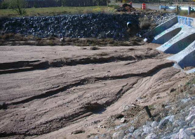
The road goes over, rather than through it. The local acequia dumps on the river side of the bridge, digging a hole where the water falls. As a result, the one side of the arroyo is more than twice as deep as the other.
Even when it’s not running, open sections of the ditch that runs back the Santa Cruz river collect rain water. After Wednesday’s rain, the point where it falls could be seen in the shelf of sand it carved in the bottom.
Three large culverts carry water under the road. They force water into narrow channels which dig nearly a foot into the soft ground on the upriver side. In the summer, the heat dries the land and the wind smooths the edges, eventually carrying away much of the temporary island.
This arroyo, like the far one, has its sources three or four miles away in the Barrancos badlands that parallel highway 285 that runs from Pojoaque to Española. The rains bring down debris and weeds, especially Russian thistles, that are stopped by the culverts and sometimes block them.
While I think of the arroyo as having two sides, the deep one caused by the acequia and the swallow one carved by the culverts, both acts of man appear on both sides.
Last summer, a lateral was added to the acequia that now dumps just before the bridge on the upstream side. However, with this year’s drought, it hasn’t had a chance to run enough yet to have much impact.
And, on the other side of the bridge, the water leaves the culverts in narrow channels that dig their own paths, especially on the side away from where the acequia dumps. Apparently, the two paths of merge and push the water to the one side.
The erosion caused by the mere existence of the bridge also endangers it. Last year, the local ditch association had to replace the culverts with longer ones and rebuild the concrete faces. At that time, they also added the stone reinforcements.
Note: Top picture is looking towards the badlands on the other side of the Rio Grande and the Jemez. The brown legs in the second and fourth pictures belong to the flume that carries over the ditch water that eventually finds its way to the far arroyo.
Subscribe to:
Post Comments (Atom)


No comments:
Post a Comment