
Two weeks ago, on June 18, I was driving from Albuquerque when I saw smoke to the west. I was somewhere in the flat lands of San Felipe and San Domingo where the road is moving to the northeast to rise to Santa Fe.
Just before the bypass exit for Santa Fe the state had posted a sign warning visibility was poor between Raton and the Colorado border. The fire changed from side to side, was sometimes straight ahead as the road changed directions. Without a compass, one is never quite sure where one is pointed in this mountainous land.
Then as I was headed north the fire stayed to the east, until I passed it coming down the Tesuque hill into the valleys below Santa Fe.
When I got home, I checked the local forest service website, nmfireinfo.wordpress.com, and learned there had been a fire burning for some time near Raton, and that there was a new one in Pacheco Canyon northeast of Santa Fe.
The land there is rugged with few homes to protect. The fire continued to burn, but had little impact on our lives. I could always see the smoke when I was in some high place in Española and every day I could see it from the city limits to Pojoaque where it disappeared behind the ridges.
Sometimes I could see smoke, greyish white and diffuse, from my back porch.
It settled into something like the local tame erupting volcano, sometimes active, sometimes not. There but no menace. Only regretted for destroying recreation lands familiar to people I work with in Santa Fe.
Instead of obscuring the land, the smoke made it more visible. Unless it’s foggy, I see the landscape as three colors. Near are the uplifts of sand, clay and rock along the river. Behind them, nearly the same color, are harder rock. Behind them are the Jemez to the west and the Sangre de Cristo to the east, usually dark shadowy forms.
When the smoke drifted up from the Wallow fire in Arizona, it hid the mountains, then the ridges, then the bad lands. Everywhere people commented on losing the mountains, and would take pictures of what wasn’t there.
This fire was nearer. In the mornings I could see the smoke drifting through the valleys. Because the intervening ridges were different distances from the center of the fire, the density of the smoke varied. The detail that was normally hidden was revealed.
Top picture: The Pacheco Canyon fire, June 26 about 9:35am; taken a quarter mile from my house.
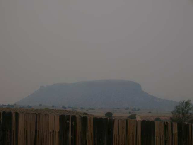
Middle picture: The Black Mesa, June 6 about 7:48pm; usually one can see the mountains behind Los Alamos, the ridges in front and the badlands. Visibility is down to about 2 miles.
No comments:
Post a Comment