Sunday, March 31, 2019

The Ditch - Crossing the Highway


[In February of 2012 I realized I didn’t know much about the local ditch, and so started hunting for it more systematically. Only the pictures are dated.]

I know as much as I’m going to know about the source of our local acequia until I go to Chimayó to look at the mother dam. It’s time to return to where I last saw the ditch, below the highway and great mound, and start to find out how it gets from there to the far arroyo.

I returned to the parking lot with all the "do not enter" signs and began walking towards the ditch, on the outside of barbed wire.


I couldn’t get very close to the diversion point, but it was obvious as I neared the utility pole where the outlet existed.


I looked across the road at an odd cut in the mound.


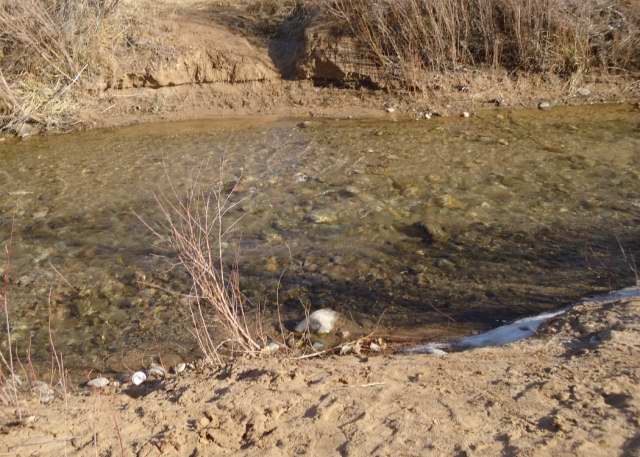
When I got across the road, I could see where the water came over. Two culverts on this side of the road, two controls on the other.


From there the concrete lined ditch began its final journey up the mound.


I still have no idea how the water does that, and it’s the wrong season to go watch. I have to wait spring when the ditches are running to see how water runs uphill.

Photographs:
1. Local acequia below 84/285, 3 February 2012.

2. Gate and fence preventing access to the land with the ditch, 17 January 2012.

3. Ditch controls below 84/285, 3 February 2012.
4. Ditch path above 84/285, 3 February 2012.
5. Water outlets above 84/285, 3 February 2012.
6. Ditch heading up the mound, 5 February 2012.

Sunday, March 24, 2019

River Rock


[I originally wrote this in February 2012, but never posted this series on the local geology. The pictures are still worth seeing.]

River rock is one of those terms used everywhere in the country that everyone knows what means and no one defines. Generally, it’s rock that has a relatively smooth surface. I say relatively, because its not as smooth as a polished tombstone, but it’s not jagged.

If you ask for something more specific, people take the adjective smooth and turn it into a verb. There the trouble begins, because they start to say things like "the erosive action of the moving water from a river smooths and shapes the stones. Other times, they say something slightly romantic like "smooth surfaces created by tumbling around in rivers for years."

Maybe, elsewhere in the country. Here, even when the Rio Grande is running high, like it was in the above picture take last October under the Griego bridge in Española, the water only creates rapids. You don’t see rocks being tossed about. More likely you see them laying outside the action where silt can filter through them.

Smoothing and polishing are not the same thing. The second is done by removing material, often by breaking large pieces into smaller ones. In a rock tumbler, the polishing is done by some kind of abrasive grit, something like silicon carbide, with water used as a facilitating lubricant, not as the active agent . The winds here move sand at high enough velocities to blast surfaces.


The above is a piece of granite I found in the area of the far arroyo this weekend. Part has striations that left a relatively smooth surface. The darker corner at the top of the picture below was untouched. There the smoothed section has a lighter color because the abrasion removed the tops of the softer, darker mica, but harder flecks of quarts remained.


The smoothing of river rocks is done by filling in rough surfaces with finer sand that drops when the river currents slow. It often is the same general material loosened by wind and deposited in the water. Eventually the sand becomes welded to the surface, like a rind.


I first noticed this with a bit of granite I picked up somewhere along route 554 north of Ojo Caliente last fall. You can see the brown outer skin is very different than the quartz and mica inner stone. If you look carefully, you can see the outer layer isn’t uniform in thickness, but penetrates in low edges to fill the rough places. That’s what creates the coarse textured, smooth feeling exterior surface.

If the river rocks were polished by removal, they’d look more like tombstones or the stone above. Instead, they look like amorphous potatoes. Round, formless, grey lumps.


Someone broke the above rock outside a near neighbor’s drive. Since he works for Cook’s Transit Mix, I assume the rock came from somewhere just north of Española. You can just see the lighter colored outer layer that built up around the granite, especially on the lower curve in the upper left had corner.


Last weekend my immediate neighbor had loads of sand brought into our shared drive by a friend of his who said it came from his yard in Velarde. A broken piece of granite filled with quartz and mica landed near my gate.


Again, you can see the boundary between pock marked grey shell and the uneven texture of the broken face. It may looked like it’s been smoothed by removal, but if you look closely you can see the uneven fill that protects the bright interior with a dull overcoat. In places it has even started to colonize the surface.

Sunday, March 10, 2019

The Ditch - The Dam

[In February of 2012 I realized I didn’t know much about the local ditch, and so started hunting for it more systematically. Only the pictures are dated.]

I could see nothing more of the Santa Cruz river along 84/285, so I drove along the Santa Cruz road searching for some place the river was visible. I found it at the Branch Bridge on Route 106.


Upstream, it’s the obvious continuation of the river seen in town. Downstream, there’s a concrete faced dam that sends water off to the left where there are four gates. Three, closed now, divert the water into the local ditch. The other, at a right angle and open now, sends the water back into the river.


The water runs hidden in a culvert under the access road to emerge a bit downstream in a natural ditch shrouded by trees.


It continues in that dirt lined ditch for some feet until it approaches another concrete dam.


This is the true beginning of the ditch. When the gate to the right is down, water backs up in that dirt ditch until it reaches the slot in the concrete. At that point water enters the ditch proper.


When the ditch is not in use, like now, the gate is raised, and the water enters a canal that takes it back to the river.


In normal times the river remains as placid here as it is in town.


When water levels are high, especially when it rains in summer, the water first backs up into a spillway behind the dirt ditch.


Water can also back up behind the dam, as it must have done last summer.


This dam is relatively new. The Santa Fe New Mexican for 15 May 1989 said it had been dedicated that week and replaced an earlier earthen dam at the same location.

Photographs:
1. Santa Cruz river at the Branch Bridge, looking upstream, 27 January 2012.

2. Diversion gates on Santa Cruz dam, 10 February 2012.

3. Entry point for water from the dam into the transit ditch, 10 February 2012.

4. Control point of entry for the local acequia, 10 February 2012.

5. Control point of entry with local acequia reach downstream, 10 February 2012; the great mound facing 84/285 is just visible in the back.

6. Return channel for water not used in the local acequia, 10 February 2012; the tree has been cut and left blocking the movement of high objects into the Santa Cruz river.

7. Santa Cruz river downstream from the return channel, 10 February 2012.

8. Spillway for the transit ditch, 10 February 2012; the light bank in the center back is the hump separating this from the actual ditch. The culvert in #3 is under it.

9. Land between the dam and the river seen in #1, 27 January 2011.

Sunday, March 03, 2019

The Ditch - Left Bank

[In February of 2012 I realized I didn’t know much about the local ditch, and so started hunting for it more systematically. Only the pictures are dated.]

Now that I knew where to find the first legs of the local acequia, my next step was to trace the Santa Cruz river back to the diversion point. I began where the tributary enters the Rio Grande just north of the Griego Bridge in Española. Except at the water’s edge, where mechanical equipment can’t go, the land there’s been kept barren. It’s on the perimeter of a toxic dump site that’s actively being remediated.


The next place up stream I knew I could see the Santa Cruz was at the Riverside Drive (route 68) bridge. There the banks are more defined, perhaps because there’s no back flow from the confluence with the Rio Grande to erode them.


Immediately upstream, the river recovers its natural vegetation pattern, or at least the one that’s come back and been left relatively undisturbed.


From there I drove into the first large commercial parking lot I found on the east side of the road. Behind the business, a large area had been scraped bare of any vegetation. Behind that wasteland, some cottonwoods had come back.


Beyond the trees, I found the river, apparently far enough away from any building that its course was left unmanaged. It had carved itself a winding path through sedimentary soils that varied by deposition, avoiding rocks where it could, eroding softer areas at will.


The depth was controlled by dams upstream, but the bottom was still littered with river rock.


I tried another parking lot, a bit farther upstream, where the grasslands before the cottonwoods were less disturbed. I could see houses through the trees that had to be on the other side of the river. However, a well-maintained chain link fence kept me confined to the parking lot.


There was one parking lot left to try before the highway started its climb out of town. The land owners there were definitely tired of people confusing their drive with a public road. There could be no explanations of innocence if I went down that road lined on the right by cottonwoods.


I’d seen as much as I was going to see of the left bank of the Santa Cruz.

Photographs:
1. Santa Cruz river just before it enters the Rio Grande, 29 December 2011.

2. Santa Cruz river just before it goes under highway 84/285, 20 January 2012.

3. Santa Cruz river upstream from 84/285, 20 January 2012; red sandbar willows marks the banks of the river.

4. Approach to Santa Cruz river from behind a business on 84/285, 20 January 2012.

5. Santa Cruz river behind a business on 84/285, 20 January 2012.

6. Santa Cruz river behind a business on 84/285, 20 January 2012.

7. Santa Cruz bosque behind a second business on 84/285, 20 January 2012.

8. Gate blocking access to the Santa Cruz behind a third business on 82/285, 20 January 2012.