Sunday, December 30, 2018

The Ways of Water

[I originally wrote this in November 2011, but never posted this series on the local geology. The pictures are still worth seeing.]

On my way back from the Barrancos I followed the path left by water. This was less a point of curiosity than the easiest way to negotiate broken land. The rivulet began somewhere in the hillocks below the fan before the cliffs.


From there the water wound through low hills.


The water reached more gently sloping ground, where its path was marked by the lack of vegetation. Once in a while, the bottoms was littered with gravel it had recently picked up, but mainly it was a slightly shinier, more level continuation of the banks.


When it reached a more level area where sedimentary gravel covered the ground, it spread wider. Juniper trees grew along both sides.


Below the junipers softer soils appeared. The line was crossed between Tertiary and modern alluvium. Water was no longer able to define a specific course. It spread into a flood plain, leaving areas bare of vegetation. The only clues for where water had flowed were gravel deposits.


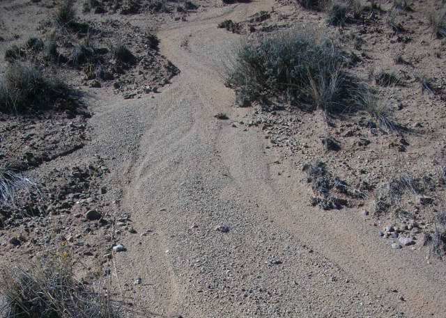
The water was flowing generally northeast toward the arroyo when it collided with an ATV trail headed straight for the north end of the cliffs. The water ricocheted back. It was lower than the trail.


From there it ran parallel to the ATV track, preternaturally straight. Its depth varied with soil. When it found something soft, it was deep. One time it was deep, a wash was opening on the other side of the track. At another the banks were caked with grey mud.


When a particular grass was resistant, it disappeared in the shadows.


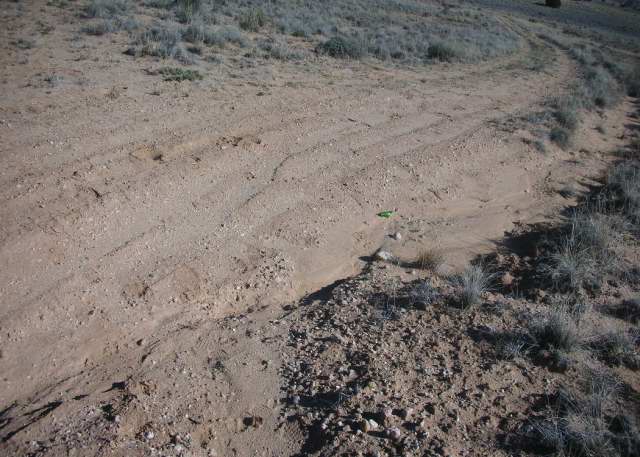
When it encountered another channel coming from the southwest, it got lost in another flood plain, until the channel reformed next to the ATV track.

The pattern repeated itself: a straight run, a collision with another water stream, a confused path, rationalization along side the higher road.


Then, a competing channel came through at just a point in the descent where the ATV track was nearly level with my water path. The abutting channel swept across the track, pulling my stream in its wake.


An arroyo feeder formed in the softer soils, twisting and turning around small changes in the earth. Sometimes, one side was steep and the other a delta; it other places the sides were the same. It behaved again like one would expect water to behave.


Just before it reached the arroyo there was a small washout, perhaps formed when water was backup during a storm by stronger currents in the far arroyo.

The feeder entered the arroyo downstream from where the ATV track began. The water dropped its final load of stones as it changed course when it met the waters in the arroyo. From there it flowed towards the Rio Grande.

Tuesday, December 25, 2018

Valley of the Arroyo


[I originally wrote this in November 2011, but never posted this series on the local geology. The pictures are still worth seeing.]

Yesterday I walked to the closest Tertiary formation in the Barracanos badlands. From the base I looked back towards the formations on the other side of the arroyo. A valley I’d never recognized spread out below. The arroyos and washes that dominated when I was in the valley had disappeared.


A few days before I’d walked downstream along the top of the left bank between the ranch road and the area widened by the irrigation ditch. In that small area I could see the level I called the second bottom existed on both sides and appeared to be the same height.


This isn’t a glimpse of the Tertiary past. Rather, this is what remains after waters filled, then retreated, waters that rose to different heights at different times.

Note: Picture 2 is looking down on the second bottom. In picture 3 the bottom continues on the opposite side in the space between the two bare banks.

Sunday, December 16, 2018

Early Beginnings

The early history of the earth is more theory than fact, and those theories are taken more from astrophysics than other disciplines. Those with other interests tend to pick through the available information in hopes of arriving at some early history for their subject.

A great many look for the thread that explains the origin of life. Others want to know how the moon was made.

My focus has been the creation of the conditions that made possible the emergence of that part of the North American plate where New Mexico sits between 1710 and 1600 million years ago, with a certain inclination to pay some attention to the formation of Michigan, the state where I was raised.

For me, this means envisioning how a 4600 million year old cloud of gas and dust evolved into a stratified ball whose layers have been defined by the workings of heat and cold.

The most important element has been iron. According to Wikipedia, iron begins in stars hot enough to burn silicon and initiate a chain of reactions with helium that transform matter from silicon to calcium to titanium to chromium to an unstable iron. That iron fuses with a helium nucleus to create 56nickel, after which the star collapses and the 56nickle transforms into 56iron via 56cobalt.

During the earliest millennia of the planet, radioactive decay continued in particles of nickel in the cloud which created conditions warm enough to heat the iron dust whose melting point is 1535 degrees centigrade. Following one basic law of physics, liquids are heavier than gases, the molten iron would have begun to isolate itself from the heat generating gases.

As it moved away from the source of heat, the molten iron would have gone through several structural phases. When the temperature fell below 1540 degrees centigrade, it would have begun to solidify and at 770c degrees it became magnetic.

Following another simple rule of physics, heat rises and cold falls, the cooler materials would have drifted towards the center of the ball, and the gases remained on the surface. Once enough iron had fallen below 770c degrees, the magnetic core could form. This process took about 50 million years and was complete around 4535 million years ago.

Once the nickel and iron coalesced into a ball divided into two parts, the magnetic, solid inner core and the molten outer core where temperatures today range from 5000c to 2200c degrees, silicon, magnesium and similar elements were segregated into an outer layer. Steve Kershaw suggests the mantle emerged around 4000 million years ago, and that it took about 2000 million years for the separation to be completed sometime around 2000 million years ago.

While the interior was still evolving, the outermost layer cooled into a skin that became the precursor of the crust. The oldest rocks found so far on the North American plate are from the Nuvvuagittuq greenstone belt near Hudson Bay. They are estimated to be between 3800 and 4280 years old.

The skin created a barrier between the warmer interior and the lighter gases which allowed water to condense without turning into steam. Oceans existed more than 3900 years ago, according to Kershaw. Scientists argue whether all the water was native or was increased by collisions with meteors and comets which could still easily penetrate the surface gases.

At this point, the history of the earth diverges into four separate narratives - the mantle and its skin, the oceans, the gases, and the crust and its plates - which rejoin sometime before New Mexico makes its appearance on the stage.

Notes:
Chandler, Harry. Metallurgy for the Non-Metallurgist, 1998, on properties of iron.

Kershaw, Steve. "Precambrian Ocean Change" in Oceanography: an Earth Science Perspective, 2000, with contributions from Andy Cundy.

Wikipedia entries on Earth’s history and iron.

Sunday, December 09, 2018

Ranch Animals


[I originally wrote this in November 2011, but never posted this series on the local geology. The pictures are still worth seeing.]

Last week I returned to the washes that lay to the right when I was following the road south of my fence. The thing that originally struck me was that the wash stopped at the fence that marked the boundary with pueblo land.

I couldn’t see how nature would respect mere strings of barbed wire and sapling posts. I supposed it was possible, given the way the land varies, that whoever claimed land out of the pueblo grant followed some natural indicator, say the variety of grass which reflected something about the underlying soil structure, but I really couldn’t credit the idea much.

I turned to follow the fence towards the arroyo and found something strange. Maybe ten feet to the side of the barbed wire boundary was a line of farm fence topped by several lines of barbed wire creating a sort of no-man’s land between. The gully began at the farm fence post.


The lane ended abruptly with a line of barbed wire cutting between the two fences and a wash that made it nearly impossible to walk by. The boundary fence continued to the arroyo; the farm fence stopped. It could have been some kind of animal enclosure, but I couldn’t really see what or why.


Yesterday, I went back to the near arroyo to follow the right bank back to the cactus field. The arroyo maintained its lake like appearance on this side of a barbed wire fence marking the pueblo boundary.

I followed the bank back to its farthest corner where I found the remains of wooden chutes used in some way to corral animals. If the current width is any indication, it was probably sheep rather than cattle.


There had been similar remains on my uphill neighbor’s land and in the barbarian’s wash near the road, but they’ve since been cleared away.

As I looked out over the land, the eroded gullies were, for the most part, limited to the private side of the fence like they were further south.

I now wondered exactly what animals could have done to precipitate the natural forces that were uncovering the older landscape. If the contours existed then, I suppose they would have followed the valleys were grass might be lusher and eaten the ground bare, leaving it open to wind and water.


I suppose it’s also possible that the softer spots in the land caved under their weight, and those low spots became the targets of the weather. Between the gullies, the land remains grassy knolls that hide the open trenches. The steppe scrub that returns with overgrazing appears in limited patches in the washes and nearest the road and ATV trails.

Thursday, December 06, 2018

Gravel Heap


[I originally wrote this in November 2011, but never posted this series on the local geology. The pictures are still worth seeing.]

As I got nearer home, a line of bare dirt caught my eye. It appeared to be a berm outlining a square filled with piles of gravel.

The imagination can come up with explanations besides a geometrically obsessed gopher.

It looked a bit like an archaeological site that had had a layer removed and sifted. However, I doubt any archaeologist would do the sifting within the confines of an excavation.

Another possibility was that it had once been a much taller pile of gravel, perhaps like the cone, and someone had sieved it to take away the finer stones for a road or drive. They may have built the berm to keep the rock from sliding away. However, I can’t imagine why they would have bothered to create a square, rather than an encircling ring.

It remains one of those inexplicable marks humans leave on the land that the weather hasn’t yet erased.

Sunday, December 02, 2018

Tertiary Hill


[I originally wrote this in November 2011, but never posted this series on local geology. The pictures are still worth seeing.]

On the way back from the Barbarian’s Wash I noticed a hill that had grass growing at it’s base, but was bare at the top. Oddly it supported several junipers.

The slope wasn’t steep. Up I went.

The grass gave way to what looked like caked mud.


Only it wasn’t. I picked up a piece, and found it was thin rock of no particular distinction.


I continued to the top where the fragments began to take on the shape of some kind of flow over what must have once been soft mud.


If the washes were slowly revealing some previous landscape, this hill top represented how deep those sediments must have been. Presumably, the land was all at this height at some time, but the rock kept this from being eroded as completely.

The junipers had found their water beneath the slabs.


When I got home I discovered the nondescript rock wasn’t some piece of rough-textured sediment, but a slice of conglomerate, I assume from the Tertiary age. How they got atop the sediments is another mystery, if indeed the sediments are younger.