Colonial life after the reconquest was different than before; Spanish Bourbons were more interested than the Spanish Hapsburgs had been in making physical claims to their empire against forays by French Bourbons and the English.
Conflicts with Apaches and other hostile groups were no longer seen as acts of the unconverted, but as extensions of European politics. People who weren’t allies could no longer tolerated. Tano speakers were forced from the Santa Cruz area, then out of Chimayó. Land was opened, and people needed to colonize it.
Earlier concerns with the loyalty of Jewish and Moorish converts to the emerging Spanish state transferred to mestizos. A new class was defined, the español, which Angélico Chávez says meant an individual who had been fully acculturated into Spanish life and was restored to trust of the community.
The first man to request land under the new regime was Angélico Chávez’s ancestor, Fernando Durán y Chaves, the younger, who requested 41,533 acres in 1692 north of modern Albuquerque, west of the Río Grande he claimed had been settled by his father before the Pueblo Revolt. However, Diego de Vargas wouldn’t let him move there until he’d completed the Reconquest.
As it was, Chávez says, Vargas had to battle Apache who’d stolen Chaves’ livestock in 1704. He became ill during that campaign and died. The Atrisco Grant wasn’t completely secure until the Tiwa speakers living in Alameda, Puaray and Sandía pueblos moved west to Hopi territory where they joined the Tano speakers who’d refused to resubmit to the Spanish.
In 1710, Francisco Montes Vigil requested more than 100, 000 acres of Tiwa land north of Chaves and west of the Río Grande in return for his services in the Reconquest. He claimed "he was retiring from the army and had acquired a small start of cattle" and so "needed the tract in order to maintain his family, which was large, and also as a pasturage for his animals."
Vigil and his wife, María Jiménez de Ancizo, had come north in 1695 in the group from Zacatecas led by Juan Paéz Hurtado. Vigil’s grandparents, Juan Montes Vijil and Catalina de Herrera Cantillana, had sufficiently established their ancient hidalgo lineage to be able to migrate from Estremadura to Mexico City in 1611.
His father, Juan Montes Vigil was an unmarried Zacatecan merchant wealthy enough to own at least one mulatto slave woman. He entered some real estate transaction there with Cristóbal Zaldívar, no doubt, some sort of kinsman of Cristóbal de Oñate.
When Francisco and his wife were interviewed by Paéz, they were able to satisfy him they were españols. They arrived in Santa Fé with their five children and a free mulatto servant.
Rather than settle the land, Vigil sold the Alameda Grant in 1712 for 200 pesos to Juan González Bas, a man descended from Juan Griego through his daughter, Isabel Bernal, who had married Sebastián González. Two years later, when he was about 49, Francisco divided 40 head of cattle amongst his children.
He remained active in the military. In 1716 he was with Felix Martínez in his war with the Hopi and in 1720 went with Pedro de Villasur to investigate French influence among the Pawnee. He was one of the few who survived an ambush. He was dead in 1730 at about age 65.
Vigil wouldn’t have been the only one to disguise personal motives in the language expected by a government trying to populate the frontier. Chaves may have said he was reclaiming his father’s land, but in fact he was requesting adjacent land. In 1705 he sold his patrimony to his sister’s husband, Manuel Baca, who owned the land to south.
Notes:
Bowden, J. J. "Town of Alameda Grant," New Mexico Office of the State Historian website.
Chávez, Angélico. Chávez: A Distinctive American Clan of New Mexico, 1989. Chávez believes the reason Chaves sold the land was his favorite son had been killed there in an accident.
_____. Origins of New Mexico Families, revised 1992 edition.
Hendricks, Rick, John B. Colligan, Charles Martínez y Vigil, José Antonio Esquibel, Stanley M. Hordes, Richard Salazar, and Robert D. Martínez. Research on Monte Vigil published on Genealogía de México Weblog
Sunday, June 29, 2014
Sunday, June 22, 2014
La Cañada - Land Use
The actual land use patterns in the La Cañada settlement before the Pueblo Revolt of 1680 are difficult to determine for two reasons. It’s not clear if differences in treatment of one man’s land from another’s resulted from actual differences or differences in reporting by Luis Pérez Granillo as his entries became repetitive. Second, it doesn’t appear the translators were consistent in their uses of English and Spanish words.
Still, Granillo seems to have described a settlement that was an embryo of what would emerge after the reconquest when the colony regulated the land allocations of community land grants. Alvar Carlson has described that in some detail in The Spanish-American Homeland.
According to him, land would come to be allocated in strips 420' wide running between highlands and irrigation ditches, so each farmer had access to bottom lands where he could grow chile, beans and corn on the heavier, more fertile soils, upper lands where he could grow fruit trees on the coarser soils, and grazing lands without irrigation. Houses were built between the farm land and the fruit land, and roads were up land on non-productive soil.
The average width was probably less a matter of legal precedent, than the amount of land that could effectively be watered by an irrigation branch. Carlson said the fields could be any length, depending on the topography.
The most important difference between La Cañada and the later long lots is there was no acequia system with a main ditch above the settlement with laterals distributing water downslope to settlers. Instead, Granillo suggested there was a single canal with homesteads of both sides.

No matter how level the land, those on the down stream side to the north would have had more moisture, especially since they were also closer to the Santa Cruz river from whence moisture could migrate under ground. They would also have had potentially more fertile land.
As it happens, Granillo indicates most of those people had suertes or agricultural lands or irrigation. The three terms were synonymous, and referred to land that could grow corn, wheat or other crops that required water. The people on the other side of the canal were said to have had lands that could support a family.
If the settlement was between the mound and the Río Grande as I suspect, it was a triangular area with the apex to the east. Men on both sides of the canal at the west end were said to have pastures or vegas. Again the two terms were synonymous. They may all have been on the less productive, more recent quaternary soils next to the Santa Cruz and Río Grande rivers where animals could forage the scrub.
The houses that were damaged by water were at the narrow end on the mound or south side. It’s likely, the men didn’t have long enough lots to build out of harm’s way. I have no idea if the use of house and houses implied more than one dwelling, or more than one building on a holding.
Carlson believes long lots developed from the rigors of farming in an arid environment and that the earlier development of such lots by the French in the 1630's in Quebec was an independent invention.

There is much to be said for that view. When Granillo was saying the larger holdings could be subdivided, it’s clear he meant they should be split lengthwise.
However, when this land use pattern is compared to that of the later Americans who came and dammed rivers to keep the water to themselves and starved those downriver or fenced common pasture lands, it’s also clear there was a cultural component in the development of long lots.
The La Cañada settlers did not believe every man in the settlement should have an equal amount of land - some had enough frontage for three along the canal, and some had barely enough for one. Some had land elsewhere and weren’t dependent on just this acreage, and some were truly yeomen.
After the reconquest, the colony would make two kinds of grants - large land grants to men like the Martín Serranos and regulated community grants described by Carlson for settlers without resources. In a sense, the latter continued Santa Fé’s early promise that every settler should be given two lots for a house and garden, two suertes for crops, and four large caballerias for grazing.
The important difference between the two periods is that the government of Spain transferred to the French Bourbons soon after the reconquest and French bureaucratic values were probably filtering through, at least in the written protocols for the community grants.
The La Cañada settlers did not have a strong sense of community or common cause, although they did care about some of their kin and their children married neighbors. They probably owed their views of equal access to water to the Moors. However, like the French, they did create a settlement where every family had access to water and every type of land needed to grow food.
Land descriptions (Name, number of families the land would support, buildings that had existed, irrigated land, unirrigated land):
North side, from west to east
* Miguel Luján - 1 - houses - lands for agriculture and irrigation - pastures
* Marcos de Herrera - 1 - no dwelling - suerte, agricultural fields
* Nicolás de la Cruz - 1 - dwelling - lot, agricultural fields - pastures
* Melchor de Archuleta - 1 - house - agricultural field - pastures
* Juan Griego - 2 - no mention - suerte - pastures
* Sebastián González - 3 - no mention - lands
* Francisco Xavier - 2 - houses, torreón - ample lands
* Pedro de la Cruz - 1- house - lands
South side, from east to west
* Bartolomé Montoya 1- house, arroyo damage - lands
* Diego López - 1 - house, torreón - lands
* Marcos de Herrera - 1 - house, destroyed by arroyo - land
* Convento of Santa Clara pueblo - suerte
* Francisco Gómez Robledo - 1 - house
* Ambrosio Sáez - 3 - dwellings - land planted by natives - vega
* Agustín Romero - 1 - not mention - fields - middle of vega
Notes:
Carlson, Alvar W. The Spanish-American Homeland, 1990.
Granillo, Luis. Report for 12 March 1695 describing the settlement of La Cañada, included in Blood on the Boulders: The Journals of Don Diego De Vargas, New Mexico, 1694-97, volume 2, 1998, edited by John L. Kessell, Rick Hendricks, and Meredith D. Dodge.
Photographs:
1. Simple irrigation system in Cundiyo valley, 23 March 2012; the Río Frijoles is flowing across the photograph (you can just see some water in the center back) and irrigation channels have been dug to both sides (marked by taller vegetation). The land hasn’t been leveled; it’s used for pasturage. Horses were there last week.
2. Long lot near La Puebla, 23 March 2012. The Santa Cruz river is at the back, before the Tertiary mound, where the cottonwoods are growing. There is probably a ditch to the right, marked by the red branches of sandbar willow.
Still, Granillo seems to have described a settlement that was an embryo of what would emerge after the reconquest when the colony regulated the land allocations of community land grants. Alvar Carlson has described that in some detail in The Spanish-American Homeland.
According to him, land would come to be allocated in strips 420' wide running between highlands and irrigation ditches, so each farmer had access to bottom lands where he could grow chile, beans and corn on the heavier, more fertile soils, upper lands where he could grow fruit trees on the coarser soils, and grazing lands without irrigation. Houses were built between the farm land and the fruit land, and roads were up land on non-productive soil.
The average width was probably less a matter of legal precedent, than the amount of land that could effectively be watered by an irrigation branch. Carlson said the fields could be any length, depending on the topography.
The most important difference between La Cañada and the later long lots is there was no acequia system with a main ditch above the settlement with laterals distributing water downslope to settlers. Instead, Granillo suggested there was a single canal with homesteads of both sides.
No matter how level the land, those on the down stream side to the north would have had more moisture, especially since they were also closer to the Santa Cruz river from whence moisture could migrate under ground. They would also have had potentially more fertile land.
As it happens, Granillo indicates most of those people had suertes or agricultural lands or irrigation. The three terms were synonymous, and referred to land that could grow corn, wheat or other crops that required water. The people on the other side of the canal were said to have had lands that could support a family.
If the settlement was between the mound and the Río Grande as I suspect, it was a triangular area with the apex to the east. Men on both sides of the canal at the west end were said to have pastures or vegas. Again the two terms were synonymous. They may all have been on the less productive, more recent quaternary soils next to the Santa Cruz and Río Grande rivers where animals could forage the scrub.
The houses that were damaged by water were at the narrow end on the mound or south side. It’s likely, the men didn’t have long enough lots to build out of harm’s way. I have no idea if the use of house and houses implied more than one dwelling, or more than one building on a holding.
Carlson believes long lots developed from the rigors of farming in an arid environment and that the earlier development of such lots by the French in the 1630's in Quebec was an independent invention.
There is much to be said for that view. When Granillo was saying the larger holdings could be subdivided, it’s clear he meant they should be split lengthwise.
However, when this land use pattern is compared to that of the later Americans who came and dammed rivers to keep the water to themselves and starved those downriver or fenced common pasture lands, it’s also clear there was a cultural component in the development of long lots.
The La Cañada settlers did not believe every man in the settlement should have an equal amount of land - some had enough frontage for three along the canal, and some had barely enough for one. Some had land elsewhere and weren’t dependent on just this acreage, and some were truly yeomen.
After the reconquest, the colony would make two kinds of grants - large land grants to men like the Martín Serranos and regulated community grants described by Carlson for settlers without resources. In a sense, the latter continued Santa Fé’s early promise that every settler should be given two lots for a house and garden, two suertes for crops, and four large caballerias for grazing.
The important difference between the two periods is that the government of Spain transferred to the French Bourbons soon after the reconquest and French bureaucratic values were probably filtering through, at least in the written protocols for the community grants.
The La Cañada settlers did not have a strong sense of community or common cause, although they did care about some of their kin and their children married neighbors. They probably owed their views of equal access to water to the Moors. However, like the French, they did create a settlement where every family had access to water and every type of land needed to grow food.
Land descriptions (Name, number of families the land would support, buildings that had existed, irrigated land, unirrigated land):
North side, from west to east
* Miguel Luján - 1 - houses - lands for agriculture and irrigation - pastures
* Marcos de Herrera - 1 - no dwelling - suerte, agricultural fields
* Nicolás de la Cruz - 1 - dwelling - lot, agricultural fields - pastures
* Melchor de Archuleta - 1 - house - agricultural field - pastures
* Juan Griego - 2 - no mention - suerte - pastures
* Sebastián González - 3 - no mention - lands
* Francisco Xavier - 2 - houses, torreón - ample lands
* Pedro de la Cruz - 1- house - lands
South side, from east to west
* Bartolomé Montoya 1- house, arroyo damage - lands
* Diego López - 1 - house, torreón - lands
* Marcos de Herrera - 1 - house, destroyed by arroyo - land
* Convento of Santa Clara pueblo - suerte
* Francisco Gómez Robledo - 1 - house
* Ambrosio Sáez - 3 - dwellings - land planted by natives - vega
* Agustín Romero - 1 - not mention - fields - middle of vega
Notes:
Carlson, Alvar W. The Spanish-American Homeland, 1990.
Granillo, Luis. Report for 12 March 1695 describing the settlement of La Cañada, included in Blood on the Boulders: The Journals of Don Diego De Vargas, New Mexico, 1694-97, volume 2, 1998, edited by John L. Kessell, Rick Hendricks, and Meredith D. Dodge.
Photographs:
1. Simple irrigation system in Cundiyo valley, 23 March 2012; the Río Frijoles is flowing across the photograph (you can just see some water in the center back) and irrigation channels have been dug to both sides (marked by taller vegetation). The land hasn’t been leveled; it’s used for pasturage. Horses were there last week.
2. Long lot near La Puebla, 23 March 2012. The Santa Cruz river is at the back, before the Tertiary mound, where the cottonwoods are growing. There is probably a ditch to the right, marked by the red branches of sandbar willow.
Sunday, June 15, 2014
La Cañada - Location

Ever since I read Luis Pérez Granillo’s survey of the settlement of La Cañada as it existed in 1680, I’ve wondered where it was, beyond south of the Santa Cruz river.
As near as I can tell, the distance between the Río Grande and the badlands that enclose the Española valley on the east is about 2.6 miles that can be broken into three sections.
One runs from the main river to the great mound. Daniel Koning’s geological map of the area shows that while the immediate river bank is recent quaternary (Qay2), most of the land is older quaternary (Qay1). The modern village of San Pedro lies ninety degrees south of this area along the Río Grande in the older quaternary zone.

A second section runs directly between the north end of the mound and the Santa Cruz, south of the modern church. Koning says this land is also modern quaternary. Most of this land is now vacant.
Third, there’s a wide expanse of land northeast of the mound that runs east along the river to the badlands. Koning identifies this as modern quaternary. Sombrillo exists in patches of older quaternary land on the southeast margins of the area.

If one assumes for the moment, that a suerte, the unit of irrigated land for growing produce, was roughly 420' wide, then there could have been twelve to the mile.
Granillo indicated there were eleven units on the north side of the arroyo and nine on the south with some unusable land near the east end of the south side.
This would mean the community stretched about a mile along the river, somewhere in the 2.6 miles available.
It’s easy to think it was immediately south of the current church, which would mean it ran from the badlands west.
However, it’s just as easy to think the new villa of Santa Cruz was sited to the west, expanded east in the 1700's until there was no more usable land, then moved north to its current location.
The real problem with considering the location of the original settlement is the meaning of the word cañada in 1695. Today, Rubén Cobos defines it as "a dry riverbed; a small canyon in the sierra." Others simply say it means an arroyo.
The Sangre de Cristo are too far for there to be a canyon on this side of the river, and they wouldn’t have settled along a dry riverbed unless they could have converted it into an irrigation ditch.
Some comments made by Francisco Domínguez after he reviewed the Franciscan missions in 1776 are more suggestive. After noting Santa Clara pueblo was "established on a fairly good plain almost like the one that extends from the Villa de la Cañada to San Juan," he added:
"Toward the west of the plain mentioned here, there is a cañada that comes from the said sierra, runs to the east, and ends near the north side of the church, with its mouth at a distance from the pueblo."
He then indicates the agricultural lands were "watered by a small river that runs through the middle of the cañada."
He’s using the word plain to describe the older quaternary flat lands between the badlands and the Río Grande, and so a cañada can’t be that land. Instead, it sounds like he’s referring to the dry banks of a perennial river. They are distinct from the land between the church and the Río Grande, which might have been bosque or recent quaternary, and from wet banks that would have been called ciénega.
This leads me to think the original settlement was a little east of the Río Grande in the area now buried by 84/285 and the road over the Griego Bridge. Granillo says that after "crossing the Río del Norte to the right, I saw and found the hacienda that belonged to Miguel Luján." In contrast he noted the Santa Cruz river was "about three-quarters of a league" from Santa Clara where he began, a distance of roughly 2.5 miles.
Today it’s difficult to distinguish any older settlement patterns from the overlay that accumlated along the Santa Fé-Taos highway that crosses the area at an angle. There probably are no houses earlier that the late nineteenth century; adobe was replaced when more durable materials became available.
Perhaps the best evidence of older land uses are the ditches that come directly from the Santa Cruz through commercial land, cross under the road and disappear in the hodgepodge of housing that’s developed in recent decades.
One goes along the parking lot of the Shell Station.

Another goes along the parking lot of the Zia Credit Union.

Although, they probably are also recent, they suggest a different orientation of settlement vis a vis the river than has existed since the highway was built.
The identity of the arroyo is a puzzle. I’ve seen no arroyos in the area north and east of Arroyo Seco. If could be something that ran off the mound that’s since been filled and blocked. Or, it could be something from the badlands.
It’s also possible it was the irrigation system that ran through the center of the settlement. Granillo doesn’t describe any ditches, and so he, or his translator, may have been using that term for the main canal. Like the modern ditches, it may have been too irregular to be called an acequia.
The houses that were destroyed then may have been too near the upstream end of the ditch and been destroyed when a surge of water came through. While the area was vacated after the Pueblo Revolt no preventive maintenance would have been done to any barrier or dam that would have protected the first buildings.
One can think of two reasons for settling somewhere south along the Santa Cruz rather than on the larger tract of early quaternary land north of the river that was developed in the 1700's. The mound would have provided some protection from both southern winds and unexpected visitors.
More important, a poorly constructed cart going north from Tesuque or San Ildefonso would have had to traverse a number of arroyos, including Arroyo Seco, to get to La Cañada but it wouldn’t have had to cross a running river. The route Domínguez described in 1776 was probably much older, and its fragments probably still exist.

"Going north from San Ildefonso, the road leads for a while among broken hills, with a little mesa halfway (it is called the mesilla de San Ildefonso) which stands on the left side of the road. It always runs upriver and in sight of the Río del Norte and finally comes out on the plain, where, 2 leagues from San Ildefonso, the Mission of the Villa Nueva de Santa Cruz de la Cañada lies."
Notes:
Cobos, Rubén. A Dictionary of New Mexico and Southern Colorado Spanish, 1983.
Domínguez, Francisco Atansio. Republished 1956 as The Missions of New Mexico, 1776, translated and edited by Eleanor B. Adams and Angélico Chávez.
Granillo, Luis. Report for 12 March 1695 describing the settlement of La Cañada, included in Blood on the Boulders: The Journals of Don Diego De Vargas, New Mexico, 1694-97, volume 2, 1998, edited by John L. Kessell, Rick Hendricks, and Meredith D. Dodge.
Photographs:
1. USGS map for Española quandrangle showing Santa Cruz river between the badlands to the right (east) and Río Grande to the left (west). The county line goes through the mound. The red line is 84/285.
2. Fallow field back from 84/285 with the mound in back, 17 January 2012; it’s about a half mile due south of the river, and a quarter mile south of the boundary between lower and upper quaternary zones.
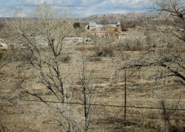
3. Land between the mound and Iglesia de la Santa Cruz de la Cañada, 27 January 2012; the white buildings are on the other side of the river.
4. Land east of the mound, south of Santa Cruz, north and west of badlands, 29 March 2012.
5. Ditch along side of Shell station parking lot, 20 January 2012.
6. Ditch along side of Zia Credit Union parking lot before it goes under 84/285, 20 January 2012.
7. Road going back to the Black Mesa looking south toward San Ildefonso, 22 February 2012. It meets the road in the middle which skirts a well-maintained fence protecting the mesa from trespassers. Someday, I may follow that road, but I don’t expect to get any closer to what is considered sacred ground.
Sunday, June 08, 2014
La Cañada - The Romeros
La Cañada may have been hours from Santa Fé, but it wasn’t allowed to remain isolated. The Inquisition reached wherever there was a friar. Its few persecutions coupled with memories from Spain and México City were enough. Fear of suspicion kept society fragmented, even in times of crises.
The life of Bartolomé Romero and his family illustrates the many ways a cultural heritage of intimidation and informing was perpetuated.
He was born in Corral de Almaguer near Toledo to Bartolomé Romero and María de [Ad]eva. Stanley Hordes thinks the half obliterated name on his baptismal certificate may originally have been Benavedas. In 1574, the Inquisition in México City argued Diego de Ocaña was Jewish because his mother was a Benadeves and "the Xuárez de Benadeva family, Jews of Sevilla, is widely recognized in being of the generation of Jews."
While still in México Bartolomé married Luisa López Robledo, daughter of Catalina López and Pedro Robledo. Robledo had been born in La Carmena, then moved to nearby Toledo where he sought confirmation of his pure Christian ancestry by becoming a lay collaborator, a familiar, of the Inquisition at a time when the Robledo name was still associated with conversos.
Whether or not they had any Jewish ancestry, Romero and Robledo were among the first to enlist with Juan de Oñate. Later, Romero and members of his family were called by the Inquisition to provide evidence against their neighbors and in-laws. Whether they cooperated because they were true supporters of the Franciscans, or because they adopted that role to deflect suspicion is a question best left to those who study human behavior under extreme situations.
In 1632 Bartolomé made his first recorded report. Alameda pueblo was performing "strange rites."
Bartolomé Romero and his wife had three sons and two daughters. Ana married Francisco Gómez and María married Gaspar Pérez, a Flemish armorer who had close relations with the Apache.
María’s son, Diego Romero, is the one who was indicted with Gómez’s son Francisco, and prosecuted separately by the Inquisition for meeting with the Apache while leading the supply train that brought López de Mendizábal north. He was banished to Parral. His wife, Catalina de Zamora refused to follow. She was the daughter of Pedro Lucero de Godoy which made her María’s niece. When Diego remarried in exile, the Inquisition arrested him for bigamy. He died in jail in Veracruz.
María Romero gave evidence against Beatriz de los Ángeles and Juana de la Cruz, wife of Juan Griego’s son.
Bartolomé’s son Bartolomé and grandson Diego had been with another of the indicted conspirators, Nicolas de Aguilar when he was arrested. The others in the group were Andrés López Sambrano and Juan Luján. Andrés brother, Hernán, had died when he betrayed Beatriz and was bewitched.
Antonio López Zambrano testified against Francisco Gómez Robledo. Chávez doesn’t mention Antonio, but says Andrés’s daughter, Josefa López de Grijalva, was married to Lucero’s son, which made Gómez’s sister, Francisca, his mother-in-law.
Bartolomé Romero, the oldest son of Bartolomé who was with Aguilar at Isleta, married María Granillo del Moral, daughter of Francisco Pérez Granillo. A son and a daughter moved to the mining area of Sonora. His other son, Bartolomé Romero, married Josefa de Archuleta, then disappeared from the public record. She was the daughter of Juan de Archuleta.
He gave evidence against his daughter-in-law’s neighbors, Beatriz de los Ángeles and Juana de la Cruz.
Her father, Francisco Pérez Granillo, appeared as a government clerk in 1617. The livelihood of her brothers came from the supply trains after they were run by civilian contractors. Alonso Pérez Granillo had an estancia near Alamillo, but moved to Nueva Vizcaya by 1680 where he was the alcalde mayor of the wagon trains and Janos.
Francisco Pérez Granillo the younger was in charge of the wagon trains in 1661 and 1664. He was married to Sebastiana Romero, whose parents weren’t identified by Chávez. Their son was Luis, who was alcalde mayor of Jémez and Queres pueblos in 1680 and escaped from Jémez. He returned as Diego de Varga’s lieutenant and made the survey of La Cañada. He was childless; his wife didn’t return.
Tomás Pérez Granillo had African and Indian parents in Santa Fé and worked as a driver on the wagon trains. He resettled in México after he and his wife smuggled out the child of Juan Manso de Contreras. His relation to Luis isn’t known.
What is known is that he was an Inquisition witness against Ana Romero’s son, Francisco Gómez Robledo.
Bartolomé senior’s second son, Matías Romero, married Isabel de Pedraza, a cousin of María de Archuleta, daughter of Asencio de Arechuleta. He refused to testify against Gaspar Pérez, claiming ignorance of the situation, but María de Archuleta did testify against Beatriz and Juana.
The third son, Agustín, married Luisa Díaz. He died young and was buried at the pueblo of San Diego. He can’t have been the owner of the land in La Cañada that Luis Pérez Granillo described after passing the meadow of Ambrosio Sáez in 1695: "in the middle of that vega is the hacienda where Agustín Romero was settled at planting time, because he had fields there. One citizen with his family can live very well there."
One can only assume Agustín was the illegitimate child of one of the Romero sons, perhaps even the dead Agustín.
He wouldn’t have been the only one. Louisa Romero married Juan Lucero y Godoy, while Pedro Romero married Juan’s sister, Petronila de Salas. Chávez didn’t place either in the extended Romero family, but also didn’t indicate others with the common name Romero had moved north.
The daughter of Francisca Romero and Matías Luján was involved with either Antonio or Bartolomé Gómez Robledo, the illegitimate sons of Francisco and Bartolomé. Chávez doesn’t identify Francisca’s parents.
Alonso Romero was a servant on the hacienda of Felipe Romero. Chávez says he was really Alonso Cadimo, and was probably a child of Francisco Cadimo, who came with Oñate. The boy was ransomed from the plains Indians and settled on Felipe’s estancia with his wife María de Tapia. Juan de Tapia had married Bartolomé senior’s daughter Francisca.
Domingo Romero was one of the mestizo leaders of the Pueblo Revolt at Tesuque pueblo.
The only man who was with Aguilar when he was arrested who did not witness against any of the accused was Juan Luján. His kin in the río abajo were already supporting the Franciscans.
Notes:
Chávez, Angélico. Origins of New Mexico Families, revised 1992 edition.
Esquibel, José Antonio. "The Rodríguez Bellido Family," La Herencia, summer 2009.
Granillo, Luis. Report for 12 March 1695 describing the settlement of La Cañada, included in Blood on the Boulders: The Journals of Don Diego De Vargas, New Mexico, 1694-97, volume 2, 1998, edited by John L. Kessell, Rick Hendricks, and Meredith D. Dodge.
Hordes, Stanley M. To the End of the Earth, 2005.
Kessell, John L. Spain in the Southwest, a Narrative History of Colonial New Mexico, Arizona, Texas, and California, 2002; on Diego Romero.
Scholes, France V. "The First Decade of the Inquisition in New Mexico," New Mexico Historical Review 10:195-241:1935.
Sunday, June 01, 2014
La Cañada - Society
The picture that emerges of the society that enmeshed La Cañada before the Pueblo Revolt in 1680 is of one with barely functioning institutions and a primitive economy, torn by feuds and jealousies, segregated into isolated pockets.
The church was absent. Mass probably wasn’t available in La Cañada. The nearest friars were across the Río Grande at Santa Clara, but assigned to meet the needs of baptized Tewa speakers. The La Cañada convento that Luis Pérez Granillo said was on land owned by that pueblo is a mystery.
Any records the church kept of baptisms, marriages and deaths were destroyed in the rebellion. What little Angélico Chávez has pieced together suggests without formal rites of marriage, sexual relations began early and weren’t supervised by parents. Indeed, fathers were often setting examples by associating with native and mestizo servants. Beatriz de los Ángeles was probably more important in enforcing mores than the friars.
The government only existed as a source of income for those who received patronage. The usual civic responsibilities devolved to others. Irrigation and roads would have been the primary infrastructure projects and were probably done with native labor. Lead for ammunition was mined at Cerrilos and Tecolate north of the Sandía mountains.
The primary function of governors and overseers of the friars was to make their charges, the colony and the missions, self sufficient, if not contributors to the overall Mexican economy. Each, desirous of promotion when he returned to México, fought for control of exports and the cheap Christianized Indian labor that subsidized them. In 1630, Franciscan Alonso de Benavides had reported a large quantity of piñon and noted:
"A fanega of these is worth twenty-three or twenty-four pesos in Mexico City. People who customarily sell them earn a lot."
In 1635, the new governor, Francisco Martínez de Baeza, ordered mission converts to collect nuts for him to ship in the returning supply wagons.
In 1658, the governor, Bernardo López de Mendizábal, criticized the friars for wanting to ship livestock to México during a famine. He gave permission to send 1,000 head; the Franciscans sent 3,000 because they needed the money to buy "to buy images, organs, richer vestments, and other church furnishings."
Most men came to the colony on military assignments, but only a few remained active. What they did the rest of their lives wasn’t recorded. Angélico Chávez says his ancestor, Pedro Durán y Chaves came with the contingent of 1600 and settled in Santa Fé. By 1622, when the río abajo had become safe for settlement, he had an estancia in an area now controlled by Sandía and Santa Ana with "vast grazing grounds" and mestizo and mulatto herders and laborers managed by his wife, Isabel de Bohórques Vaca, when he was called away.
The only trades mentioned in any of the biographies were blacksmiths and translators. The first were the armorers who kept weapons functional and, according to John Kessell, were the only paid military men. The appointment was eventually monopolized by the kin of Pedro Lucero de Godoy. The translators like Juan Griego and Juan Ruiz de Cárceres often had pueblo or Mexican Indian ancestors.
Servants and muleteers weren’t named in the families recorded by Chávez. He does suggest the first were Indians brought from Tlascala by Juan de Oñate in 1598 who settled in Analco, across the river from Santa Fé, and that local mestizos slowly replaced them. The men who drove the wagons and returning livestock were probably mulattos, who left their patrimony behind.
Medicine was left to women like Pascula Bernal and Beatriz de los Ángeles. With wills and marriage certificates destroyed, it’s impossible to know how many women died in childbirth, how many widows and widowers remarried, or how many children died young.
The well documented life of Lucero may or may not have been typical. He married at least twice, and each woman bore a child nearly every year. The first, Petronila de Zamora, died sometime after the birth of the third. She was about 30 at the last known birth. There are gaps to suggest others may not have lived long enough to leave a record. In contrast, the second wife, Francisca Gómez bore six children we know, again with gaps, and lived until the Pueblo Revolt with her mother, Ana Robledo.
Of the men mentioned in these postings who made it to Guadalupe del Paso, the largest number were in their 20's. The number drops for men in their 30's and 40's and again for those in their 50's. However, if a man could survive the rigors of middle age, he would likely have lived for years. Diego López del Castillo and Hernán Martín Serrano II were both in their 80's when they arrived. Juan Luis, who was in his mid-60's then, was still being called to testify in his 80's.
From many of the confused genealogies, it’s obvious many men like the Lujáns were willing to take responsibility for the widows and orphans left by friends and relatives, a social patterns Alice Games found in Barbados in the early years when men died young and few were able to marry.
The local community was part of Santa Fé’s hinterland, though it doesn’t seem to have provided any special commodities to it. The men who were part of the economic network had encomiendas and estancias elsewhere. Francisco Gómez Robledo gathered piñon from his encomienda at Pecos for López de Mendizábal in 1660 and was using Tabira to send salt to his San Nicolás de las Barrancas estancia near Belen. Juan Luján had his land in Taos where Francisco was an encomendero.
If La Cañada wasn’t important to Santa Fé, like any frontier, it attracted people who wished to live away from the scrutiny of governors and friars. The most prominent were ones like Juan Griego, Francisco Gómez Robledo, and possibly Sebastían González, with suspected Jewish ancestors.
Perhaps more important were the many wives and consorts who were Mexican Indians: Juan Griego’s wife, Pascula Bernal; his son’s wife Juana de la Cruz and her mother Beatriz de los Ángeles; Andrés Gómez Reblodo’s wife Juana Ortiz; and the women who came with the Lujáns, Francisca Jiménez, Magdalena and Maríana.
Under the veneer of large estates owned by men like the Martín Serranos and Juan Luis, this was an Indian village where women from different cultures sometimes feuded but probably all spoke some form of Nahuatl.
It was around this group that first-generation mestizos gathered on their small plots, confident they wouldn’t experience the humiliations they would face in Santa Fé. Chávez could only guess their identity, but like the crypto-Jews, anonymity may have been what they were seeking in La Cañada.
Notes:
Benavides, Alonso de. Memorial, 1630, edited and translated by Baker H. Morrow as A Harvest of Reluctant Souls, 1996.
Chávez, Angélico. Chávez: A Distinctive American Clan of New Mexico, 1989.
_____. Origins of New Mexico Families, revised 1992 edition.
Games, Alison. Migration and the Origins of the English Atlantic World, 1999.
Granillo, Luis. Report for 12 March 1695 describing the settlement of La Cañada, included in Blood on the Boulders: The Journals of Don Diego De Vargas, New Mexico, 1694-97, volume 2, 1998, edited by John L. Kessell, Rick Hendricks, and Meredith D. Dodge.
Kessell, John L. Spain in the Southwest, a Narrative History of Colonial New Mexico, Arizona, Texas, and California, 2002.
Scholes, France V. Troublous Times in New Mexico 1659-1670, 1942.
Scurlock, Dan. From the Rio to the Sierra: An Environmental History of the Middle Rio Grande Basin, 1998; includes chronologies that summarize research of others.
Subscribe to:
Comments (Atom)